Natural disaster hotspots often intersect with COVID-19 hotspots in many geographical contexts. The interrelationship between hazards, exposure, and vulnerability needs to be examined, so risks can be assessed and ex-ante mitigative actions could be made. The article "COVID-19 and Lessons from Multi-Hazard Early Warning Systems" by Rogers et al. (2020) initiated the discussion for an all-hazards approach to national disaster risk management that encompasses meteorological, hydrological, technological, and health hazards, due to the interconnectedness of many hazards and their impacts.
Odisha State Disaster Management Agency (OSDMA) in India first encountered a life-threating meteorological hazard in the midst of COVID-19 pandemic crisis through Cyclone Amphan. In Odisha, cyclone-prone coastal districts are also home to 80% of confirmed COVID-19 cases. To prepare for the cyclone’s impact, OSDMA used probabilistic cyclone forecasts in assessing and managing the twin challenges posed by Cyclone Amphan and COVID-19.
SATARK (https://satark.rimes.int) provided OSDMA officials with early indication of formation of the cyclonic system on 11/12 May 2020. (SATARK is a web GIS-based Decision Support System that is operational at OSDMA, hosting official forecasts from India Meteorological Department (IMD) and forecasts from other reference global models.) The probability of Cyclone Amphan hitting Odisha was estimated to be around 70%. A watch was kept to assess risks based on the more certain cyclone track forecast, and considering that most cyclone shelters were being used as COVID-19 quarantine centers.
OSDMA received IMD forecast, issued on 16 May 2020, with higher probability (85%) of heavy rainfall condition with maximum windspeed of 100-120 kph in coastal and adjacent districts of Odisha (Figure 1). OSDMA assessed the risks, overlaying the cyclone’s maximum windspeed forecast with exposed population and COVID-19 case data (Figure 2).
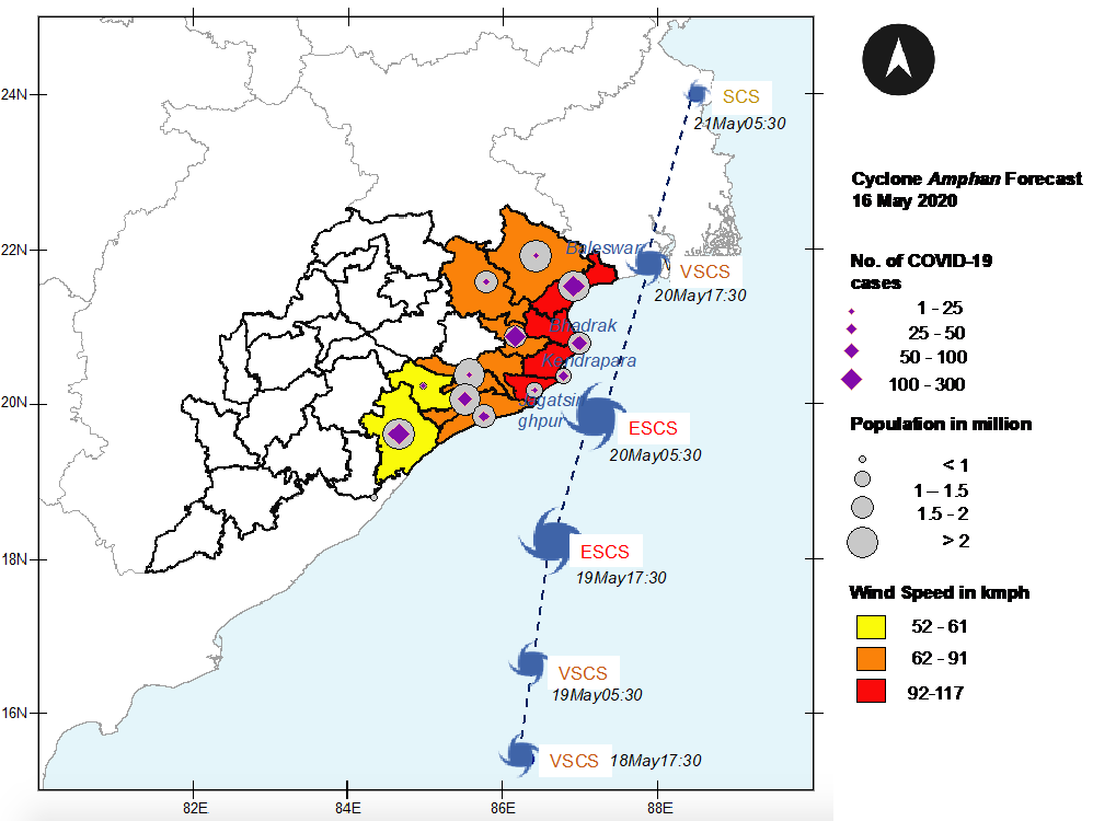
Figure 1. Map of Odisha State showing Cyclone Amphan’s track and windspeed forecasts, issued on 16 May 2020, along with exposed population and COVID-19 case data
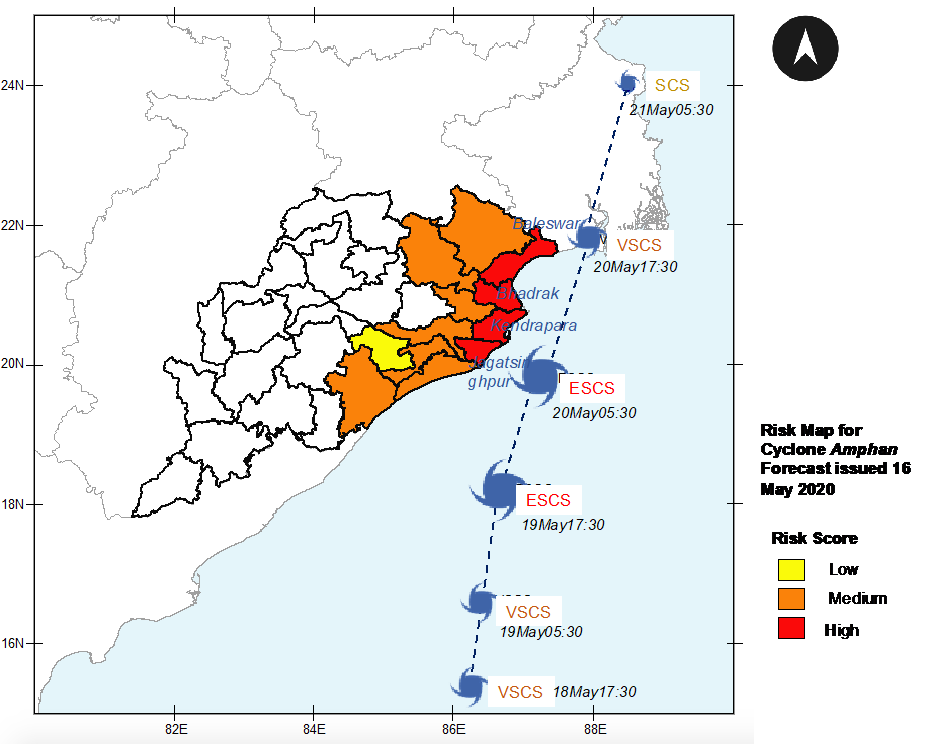
Figure 2. Risk map for coastal districts of Odisha, based on Cyclone Amphan track and windspeed forecasts, issued by IMD on 16 May 2020, population exposure, and number of COVID-19 cases
Based on the cumulative risk, OSDMA initiated preparedness activities well in advance to ensure the utmost safety and care of people at risk during the evacuation process under a COVID-19 environment. These activities included:
- Identification of 567 cyclone/flood shelters and 7,092 safe buildings for evacuating 1.2 million people in vulnerable areas
- Communication of risk information to all State departments and the public through all available media and channels
- COVID-19 re-testing of people who have been quarantined. Those who tested positive were moved to safe and secure quarantine centers.
On 19 May 2020, IMD predicted Cyclone Amphan to make a landfall on 20 May 2020 with reduced intensity along the coast of neighboring West Bengal State (Figure 3). The updated risk assessment revealed that while the cyclone-associated risk reduced, there was no change in COVID-19-associated risk (Figure 4). Based on this information, the number of people for evacuation was restricted to 200,346 from the original estimate of 1.2 million, requiring 3,998 shelters. The shelters were sanitized and prepared, based on strict COVID-19 guidelines. The government ensured that COVID-19 guidelines were strictly followed during evacuation and in the shelters. These included social distancing, use of facemask, and sanitization. The trend of COVID-19 positive cases revealed that the meticulous steps taken by the State government in managing both cyclone and COVID-19 crisis with due diligence paid off. This demonstrates the benefit of adopting integrated risk management in the face of multiple hazards, regardless of their origin.
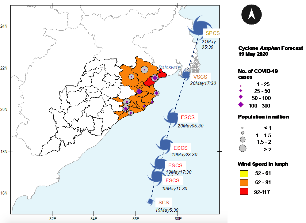
Figure 3. Cyclone Amphan track and windspeed forecast, issued on 19 May 2020, along with exposed population and COVID-19 case data
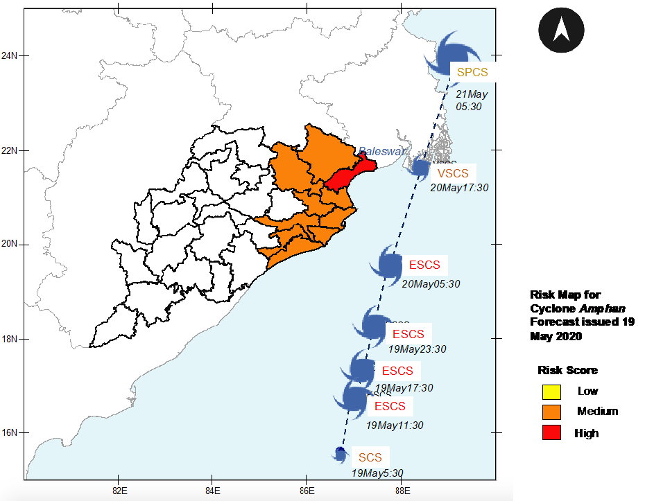
Figure 4. Risk map for coastal districts of Odisha, based on Cyclone Amphan track and windspeed forecasts, issued by IMD on 19 May 2020, population exposure, and number of COVID-19 cases
Key messages from Odisha’s experience
Dynamic decision-making is enabled by forecast-based risk assessments. Risk assessment that was based on IMD forecast, issued 4 days before cyclone landfall, informed OSDMA’s identification of anticipatory mitigative actions and implementation of measures that did not require much resources, such as identification of shelters and communication of the cyclone’s potential impacts. Updated risk assessment that was based on IMD forecast, issued a day before cyclone landfall and, thus, with much higher reliability, informed OSDMA’s definitive decision to evacuate 200,346 most at-risk people, rather than the 1.2 million people initially identified. By avoiding evacuation of so many people, the State was able to manage the COVID-19 crisis as well.
OSDMA’s emergency management could be further enhanced by integrating risk management into all phases of disaster risk management. This would involve:
- Taking a multi-hazard approach. In the current COVID-19 environment, natural disaster hotspots intersect with COVID-19 hotspots in many geographical contexts. Thus, risks need to be treated interdependently and cumulatively, from primary impacts to secondary or tertiary effects on societies and economies. The interrelationship between hazards, exposure, and vulnerability need to be examined, so risks can be assessed and ex-ante mitigative actions could be made.
- Probabilistic forecasting. Probabilistic forecasting techniques are now widely used in meteorology. Similarly, multi-model ensemble techniques have been used to forecast possible trajectories of epidemics. Probabilistic forecasting of complex cascading catastrophes may be challenging, but is critical for low-likelihood high-impact events.
- Impact forecasting and risk-based warning. Hazard data need to be combined with information on people, livelihoods, property, economy, etc., so potential impacts can be assessed, and guidance can be provided to people at risk and those responsible for mitigating the risks in a form that is understandable and actionable.
- Decision Support Systems (DSS) that assist in making effective decisions by guiding/aiding: i) the warning of threat, with sufficient lead time; ii) emergency response; and iii) long-term planning to eliminate or reduce risks.